AirVisual Earth
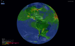
AirVisual Earth is a project inspired by Cameron Beccario's "Earth: A Global Map of Wind, Weather, and Ocean Conditions" (which we re-featured in the 1-28-2018 Scout Report) that provides a real-time visualization of air pollution around the globe. The map was created by the Swiss company I.Q. Air and illustrates air quality data collected from a number of Environmental Protection Agency (EPA) stations located around the globe. In addition, this map includes data about wind from the U.S. Global Forecast System (GFS). As visitors browse this map, they will see the Air Quality Index (A.Q.I.), represented by color.
Archived Scout Publication URL
Scout Publication
Publisher
Classification
GEM Subject
Language
Date of Scout Publication
June 1st, 2018
Resource URL Clicks
233
Comments