Map collector and cartographer David Rumsey has done a fine public service by placing thousands of his own maps online over the past decade. In the past few years, he and his colleagues have introduced new additions to the site via their friendly and interesting blog. This particular addition features some two dozen remarkable maps created by children during the 19th century. Many of these old...
Maintained by the Cartographic Research Laboratory at the University of Alabama, this collection of 3540 different scanned and digitized maps offers a valuable resource for persons doing research on the history of Alabama, or looking for contemporary thematic maps of the state. The historical maps of Alabama are divided into time periods ranging from 1803 to 1942, and can be enlarged to focus in...
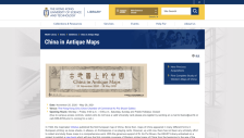
Created by the Special Collections Department at the Hong Kong University of Science and Technology Library, this fine collection of digitized antique maps will pique the interest of geographers and historians alike. The collection contains over 230 maps, charts, pictures, books, and complete atlases produced by European cartographers from the 16th to the 19th centuries. The collection serves as...
Presented by the University of California Berkeley's (UCB) Earth Sciences and Map Library, the Browse Our Digital Map Collection Web site lets visitors do just that. Several thousand scanned maps from the collection are available and can be searched via the UCB Library Pathfinder program. After orientating oneself to the peculiarities of the search program, which seems more daunting than it...
Charting the Nation (CN) includes single maps, maps in atlases, and other bound books, as well as manuscript and printed texts relating to the geography and mapping of Scotland from 1550 to 1740 and beyond. Currently, there are 2,208 images, and more will be added later this year. CN employs the Luna Insight Image Browser, which provides a handy workspace for zooming in, rotating maps, and...
Most American historians and geographers are well aware of the Sanborn fire insurance maps which document the landscape of hundreds of different cities. They are tremendously useful to a wide range of scholars and researchers. What some people may not know is that the Dakin Publishing Company of San Francisco also worked to create similar insurance maps in the late 19th and early 20th centuries....
Passionate about cartography and maps in general since his youth, David Rumsey has amassed an amazing collection of maps and map-related ephemera over the past several decades. The Scout Report has profiled this site a few times over the past years, and the online David Rumsey Historical Map Collection continues to grow by leaps and bounds. This new site is a perfect way to keep tabs on the latest...
The first site about historical maps is the US Military Academy at West Point's History Department's Map Library (1). The page contains links to dozens of maps related to warfare from ancient times, the American Revolution, and the Napoleonic wars to the World Wars and other modern conflicts. Although map descriptions are not given and the main page seemed to have a problem loading correctly, the...
Designed by librarian Matthew White, this sprawling and somewhat idiosyncratic Website offers hundreds of political, economic, demographic, religious, and historical cartographies of the countries and continents of the last century. Visitors to this site can trace the global rise and fall of various political systems through the century, examine the mapped battle histories of the Mexican...
Digitized map collections abound online these days, and the Historical Maps Online collection from the University of Illinois Library is one of the better ones available for researchers and the inquisitive public. Part of a collaborative effort between the University of Illinois Library and the University of Illinois Press, the online material includes hundreds of digitized maps, which may be...