Established in 1989 by the United Nations Environment Programme and the Norwegian Ministry of Environment, GRID-Arendal is an international information center providing high quality environmental information for practical use. Arendal is one of thirteen centers that together comprise the Global Resource Information Database, a "network of environmental data centers facilitating the generation and...
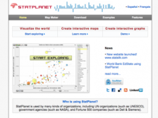
Interested in making a map? Well, StatPlanet may be just the ticket for first-timers who would like to do just that. The application is an interactive data visualization and mapping tool used by a range of international organizations and universities for a variety of purposes. Visitors can use data on over 250 world development indicators to create interactive maps, graphs, and charts. The program...
The Atlas of Canada Web site is maintained by the governmental Natural Resources Canada Agency. This excellent interactive mapping and informational device lets users choose from dozens of topics to map such as geology, hydrology, land cover, glaciers, wetlands, natural hazards, and sea ice, as well as several others such as people and society, economic, health, and more. Once a map loads, users...
This site presents some of the work produced by the UN's mapping and GIS specialists. Two primary map collections are offered at the site in .pdf format: general maps (over 100) and deployment maps of peacekeeping missions. Both can be browsed via a pull-down menu or on separate pages via the toolbar at the top of the main page. The general maps page organizes maps by region, while the...