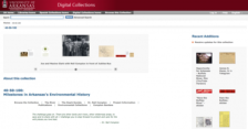
On March 1, 1972, President Richard M. Nixon signed Public Law 92-237, effectively creating the Buffalo National River in Arkansas. It was the first designated "National River" and resulted from a hard fought battle as many Arkansans were hoping that dams would be built, leading to a bit of an economic boost. This was a seminal moment for the state and the nation, and it is one of the items...
The Hudson River was one of the most prominent waterways in the frontier mythology of 17th and 18th century America, and its bends and curves have been immortalized by dozens of artists, authors, and explorers. With funding from the New York State Education Department, the New York Public Library has created this delightful website that brings together a number of rare images and texts from the...
This map from the United States Geological Survey (USGS) provides real-time data of streamflow conditions as measured at USGS gauging stations around the country. By selecting areas within a state on the map, users receive daily provisional data (which may be subject to revision) on current conditions and flood thresh-holds, as well as streamflow, stage, and rainfall graphs. Historic data and...
"The Delaware Riverkeeper and the Delaware Riverkeeper Network stand as vigilant protectors and defenders of the River, its tributaries and its watershed committed to restoring the natural balance where it has been lost and ensuring its preservation where it still exists." Users can learn about the group's extensive efforts to protect the water quality of the 13,539 square mile watershed. The...
Get the most out of National Estuaries Day (October 5, 2002) by visiting this Web site from the National Oceanic and Atmospheric Administration (NOAA). Follow a link to Estuary Live!, which offers online interactive fieldtrips through a number of estuaries around the nation. Guided tours of eight estuaries will be webcast live October 3 and 4, supplemented by videos from a number of other...
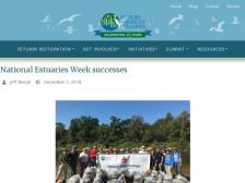
Established in 1972 through the Coastal Zone Management Act (CZMA), the National Estuarine Research Reserve System (NERR) is a network of protected areas representing different types of estuaries and biogeographic regions. Operated by coastal states with input from local communities and regional groups, NERR studies address coastal watershed management issues. The homepage provides an overview of...
Established in 1972 through the Coastal Zone Management Act (CZMA), the National Estuarine Research Reserve System (NERR) is a network of protected areas representing different types of estuaries and biogeographic regions. Operated by coastal states with input from local communities and regional groups, NERR studies address coastal watershed management issues. For reserve data and data on water...
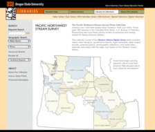
The Oregon State University Libraries has created this wonderful collection of 1,000 different images taken between 1934 and 1945 that document 390 streams in the Columbia River Basin. The photographs were taken by U.S. Bureau of Fisheries researchers who were interested in the spawning and rearing habitats for spring Chinook salmon. Visitors can use the clickable map on the homepage to move...
The mission of River Network, a non-governmental organization, is "to help people organize to protect and restore rivers and watersheds." To that end, the River Network homepage offers a wealth of information and links on rivers and watersheds including publications, upcoming conferences, watershed protection issues, river conservation job listings, related organizations, and a searchable National...
The National Weather Service of the National Oceanic and Atmospheric Administration (NOAA) has launched the River Watch site, providing up-to-date river forecast information for the nation's largest river basins: the Mississippi, Missouri, Illinois, and Ohio River Basins). Daily river level summaries are provided for each basin, in addition to five-day forecasts for river stage heights (in feet)....