This USGS Web site presents educational materials about "earth structure, earthquakes, plate tectonics, and earthquake preparedness." Teachers can search the up-to-date information by topic or by grade level (K-12). The site provides a PowerPoint presentation Earthquakes 101, which incorporates images and drawings to help educators easily explain earthquake processes. Users can take Virtual Field...
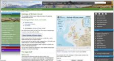
If you've ever wanted to wander from John O'Groats to the Cotswolds without leaving your desk, this most wonderful website is for you. Created by the British Geological Survey, the Geology of Britain viewer helps interested parties learn more about the landforms in their backyards. After opening the viewer, visitors can click on an area of interest to look at everything from possible earthquake...
The global and regional maps found at the Global Seismic Hazard Assessment Program show the chances of seismic activity over the globe for the next 50 years. The maps, recently made available on the Internet through the Swiss Seismological Service, were created through the collaboration of hundreds of researchers worldwide. Available here are global and continental maps (Americas, Europe/ Africa/...
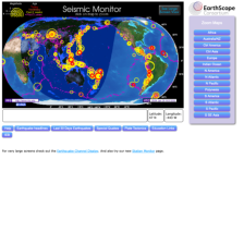
The IRIS Seismic Monitor allows users to monitor global earthquakes in near real time. Researchers can locate the geology, vault conditions, site description, station instrumentation, and additional information on stations throughout the world. Visitors can learn about the latest earthquake news, including special reports of earthquakes that significantly affected human populations or had...
Those interested in aerial photographs, satellite images, or maps as ways to conceptualize the world, will find this site interesting, entertaining, and educational. The US Dept. of Interior offers a National Atlas of the United States, an interactive resource that allows users to view part or all of the US and overlay layers of information including natural features, political boundaries, federal...
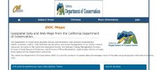
From the California Geological Survey, the Online Maps and Data site contains information focused on natural hazards. Topics include minerals, earthquakes, and landslide and erosion hazards. The site also includes the General Location Guide for Ultramafic Rocks in California. The site also has links to a publications page and a new interactive mapping program called the Seismic Hazards Mapping...
As part of the US Geological Survey, the Albuquerque Seismological Laboratory is responsible for installing and maintaining a global network of seismograph stations and collecting and distributing the data produced by these stations. The Live Internet Seismic Server (LISS) Web site provides this data free to the public from over fifty stations around the globe and is updated every 30 minutes. The...
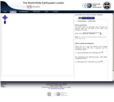
The World-Wide Earthquake Locator, developed at the University of Edinburgh, "aims to provide up-to-date information and detailed dynamic maps of earthquakes across the world within a maximum of 24 hours of their occurrence." Through online, interactive maps, users can determine the location, size, and time of recent earthquakes. While the authors concede that the prediction model is inaccurate,...
While earthquakes in the state of California may garner most of the attention of the major media, the Pacific Northwest continues to be a region of intense seismic activity. Based at the University of Washington (within the Department of Earth and Space Sciences), and funded by the USGS and several other organizations, the Pacific Northwest Seismograph Network provides a host of detailed materials...
The US Geological Survey's National Earthquake Information Center (NEIC) provides this Website for current earthquake maps (for a related USGS site of geologic hazards, see the September 18, 1998 Scout Report). Taken from the NEIC's Near-Real Time Earthquake Bulletin, maps of the world, hemispheres, continents, and sub-continents provide location and phase data for the most recent seismic events....