The United States Geological Survey's National Earthquake Information Center site offers readers near real time updates of seismological events worldwide. As one can gather from a glimpse at the report, our planet is in a near constant state of geophysical change and upheaval, given the numerous earthquakes registered on a daily basis by the NEIC, sometimes up to a dozen or more. Readers will...
The US Geological Survey Earthquake Hazards Web site contains the Earthquake Notification Services page and service. Users can subscribe to three email lists that include BIGQUAKE -- which sends a message whenever an earthquake with a magnitude of 5.5 or greater occurs anywhere in the world or a magnitude of 4.5 or greater occurs within the 50 US states -- and QEDPOST -- which sends a daily...
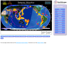
The IRIS Seismic Monitor allows users to monitor global earthquakes in near real time. Researchers can locate the geology, vault conditions, site description, station instrumentation, and additional information on stations throughout the world. Visitors can learn about the latest earthquake news, including special reports of earthquakes that significantly affected human populations or had...
The mission of the Ohio Seismic Network, with 25 stations strategically located throughout the state, is to "detect and precisely locate earthquakes within the state's borders, report the severity and potential damage from an event to emergency response officials, and to rapidly respond to media and citizen inquiries after a felt earthquake." Seismologists can view waveform data, find data on the...
Processed by Dr. Walt Silva of Pacific Engineering and supported by the Pacific Earthquake Engineering Research Center (PEER) at the University of California Berkley, the PEER Strong Motion Database "contains 1557 records from 143 earthquakes from tectonically active regions." Searches can be done by earthquake, type of plate movement (e.g., strike slip), magnitude, and several other criteria. The...
While the media tends to cover the well-known San Andreas fault when speaking about the potential danger of a massive earthquake in the Los Angeles basin, the Puente Hills fault system may in fact be equally, if not more, threatening. Discovered four years ago, the extensive fault system is capable of generating earthquakes up to a 7.5 on the Richter scale, and it runs immediately under downtown...
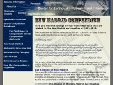
"The New Madrid earthquakes of 1811-1812 were one of the most dramatic natural disasters to strike the North American continent." At this website, the Center for Earthquake Research and Information (ERI) supplies numerous archived eyewitness accounts to these earthquakes. Visitors can search through reports about these earthquakes from three databases. Researchers can find countless references of...
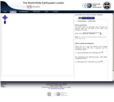
The World-Wide Earthquake Locator, developed at the University of Edinburgh, "aims to provide up-to-date information and detailed dynamic maps of earthquakes across the world within a maximum of 24 hours of their occurrence." Through online, interactive maps, users can determine the location, size, and time of recent earthquakes. While the authors concede that the prediction model is inaccurate,...
While earthquakes in the state of California may garner most of the attention of the major media, the Pacific Northwest continues to be a region of intense seismic activity. Based at the University of Washington (within the Department of Earth and Space Sciences), and funded by the USGS and several other organizations, the Pacific Northwest Seismograph Network provides a host of detailed materials...
The University of California - San Diego's Broadband Seismic Data Collection Center offers real-time and archived data, maps, and graphs of measured earthquakes from all over the world. The easily navigable website supplies information about regional networks, arrays, and portable deployments that have been collected and analyzed by the Center. Users can find extensive, comprehensible materials on...