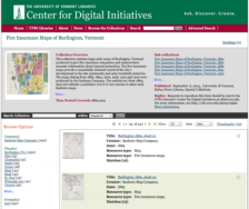
What's the best way to learn about a city's history? Is it through its historic postcards? Perhaps you'd like to read an oral history or two culled from the reminiscences of residents both known and unknown? Some might suggest the historic fire insurance maps created by the Sanborn Company from the University of Vermont Libraries is a great way to start. This collection features maps of...
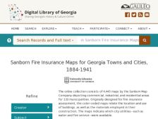
The Scout Report has profiled a number of map collections in the past, and it is always a delight to find new collections to offer to our readers. This latest collection was created as part of the Digital Library of Georgia project, and contains the Sanborn Fire Insurance maps for the years 1884 to 1922, inclusive. As some users might already know, the Sanborn maps were originally created and used...
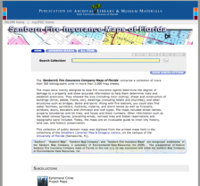
Geographers, urbanologists, historians, and long-term readers of the Scout Report know the Sanborn Fire Insurance maps quite well. Other parties can now get to know them just as well via this digital collection from the University of Florida. The maps were initially created to help fire insurance agents determine the degree of damage to a property and as such they document the size, shape and...
As with many interesting products of material culture, Sanborn Fire Insurance maps found themselves a new life as generations of historians, architects, and planners have rediscovered them over the years. The maps were originally created for insurance underwriters in the middle of the nineteenth century, and by World War II, the company had surveyed over 13,000 towns in the United States. This...
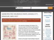
It's great to check out the corner of 12th Street and Vine in person, but if you can't make it down there, this website offers up an interesting surrogate. These digital Sanborn Fire Insurance Maps of Kansas City are provided as a public service by the Kansas City Public Library, and they consist of over 1,200 individual pages. Visitors can use these maps to research the history of a building,...