This helpful teaching tool from the United States Geological Survey brings together the comprehensive geological and topographical maps of the United States. As the site suggests, "... this digital tapestry outlines the geologic story of continental collision and break-up, mountain-building, river erosion and deposition, ice-cap glaciation, volcanism, and other events and processes that have...
Dr. Bruce Railsback of the University of Georgia's Department of Geology provides this online Atlas of Speleothem Microfabrics. Here he presents petrographic or electron microscope images of most known microfabrics found in stalagmites, stalactites, flowstones, and other chemically precipitated cave deposits. Notes Railsback, "Variation in the mineralogy, shape, size, clarity, orientation, and...
This online resource for GIS and geospatial data has compiled data from a wide range of GIS Web sites located on the Internet. Some of the data is free once you set up a user account to be part of the GeoCommunity, with additional data available for a fee using the Premium option. Downloading may require the user to be proficient in GIS and own relevant software. Download options include: Digital...
Geologic Maps are unique in that they show the distribution of geologic features on a landscape through specific symbols and colors. The United States Geological Survey's (USGS) site Geologic Maps provides visitors with a good introduction to these concepts, which include the unique features of a geologic map; the meaning of their lines, colors, and symbols; the location of faults; and more....
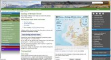
If you've ever wanted to wander from John O'Groats to the Cotswolds without leaving your desk, this most wonderful website is for you. Created by the British Geological Survey, the Geology of Britain viewer helps interested parties learn more about the landforms in their backyards. After opening the viewer, visitors can click on an area of interest to look at everything from possible earthquake...
The US Geological Survey offers the Map Showing Geology, Oil and Gas Fields and Geologic Provinces of Africa Web site and report. The agency's goal for the pieces includes assessing the undiscovered and technically recoverable oil and gas resources of the world. The site includes various descriptions of what the map depicts and how data was processed using Geographic Information Systems. Once the...
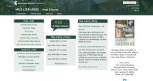
The Michigan State University Map Library website is a real find for anyone with the slightest interest in maps or mapmaking. On their homepage, visitors will find a selection of "Quick Links", which includes links to scanned maps, printable maps, and a feedback form. The scanned maps area is quite diverse, and it features over 50 maps. Some of these maps include 1873 maps of the state's Lower and...
Guess what: On the National Atlas website you can find and make thousands of maps. It's just as interesting as it sounds to let these maps "tell their own stories." This work began as part of an effort to create a new national atlas back in 1997, and since that time it has grown exponentially to include participatory mapping, fact sheets, and much more. Its "father" atlas was created in 1970 and...
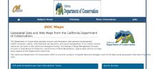
From the California Geological Survey, the Online Maps and Data site contains information focused on natural hazards. Topics include minerals, earthquakes, and landslide and erosion hazards. The site also includes the General Location Guide for Ultramafic Rocks in California. The site also has links to a publications page and a new interactive mapping program called the Seismic Hazards Mapping...
The Atlas of Canada Web site is maintained by the governmental Natural Resources Canada Agency. This excellent interactive mapping and informational device lets users choose from dozens of topics to map such as geology, hydrology, land cover, glaciers, wetlands, natural hazards, and sea ice, as well as several others such as people and society, economic, health, and more. Once a map loads, users...