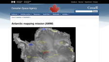
Images from the Antarctic Mapping Mission (AMM) are now available. The goal of the AMM is to complete the mapping of Antarctica using high resolution imaging. The Canadian Space Agency's RADARSAT satellite was launched in 1995, with high resolution mapping of Antarctica beginning September 26, 1997. RADARSAT furnishes standard-2 images of the south pole beginning on September 13.
Last week, scientists released images from the first high-resolution radar map of Antarctica. Taken over a period of eighteen days in 1997 by a NASA-launched Canadian satellite called RADARSAT, the images have revealed a number of amazing features never seen before. The most important of these is a complex network of ice streams, huge rivers of ice that move ice and snow from the continent's...
In a 1997 collaborative effort, NASA launched the Canadian Space Agency's RADARSAT Satellite which spent eighteen days over the Southern Hemisphere forming the first high-resolution radar maps of the Antarctic. RADARSAT's unusual capabilities make it possible to capture data even through darkness, clouds, and fog. Unveiled to the public on October 18, 1999, the new maps are so clear and detailed...