Antarctic Mapping Mission (AMM)
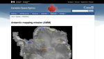
Images from the Antarctic Mapping Mission (AMM) are now available. The goal of the AMM is to complete the mapping of Antarctica using high resolution imaging. The Canadian Space Agency's RADARSAT satellite was launched in 1995, with high resolution mapping of Antarctica beginning September 26, 1997. RADARSAT furnishes standard-2 images of the south pole beginning on September 13.
Alternate Title
RADARSAT 1: Antarctic Mapping Mission (AMM)
Archived Scout Publication URL
Scout Publication
Publisher
Classification
Date of Scout Publication
October 15th, 1997
Resource URL Clicks
6
Internal
Cumulative Rating
0
Comments