USGS: Geologic Map of Alaska
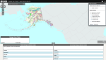
Alaska is one of the most geologically diverse states in the country, characterized by unique glacially formed rock layers and some of the tallest mountains on the continent. Professional geologists, instructors, and geology students may find this interactive geologic map, published by the United States Geological Survey (USGS), useful for navigating the complex geology of this remote U.S. state. There are several options for navigating this resource. Visitors can use the search bar to query specific locations, then click on the map for detailed data about the setting and lithography. Users can also scroll and zoom on the map itself to explore color-coded formations. The table of contents, found in the upper right corner of the map, allows for customization of features such as faults, geologic lines, or geologic units, or toggling between topographic maps and shaded reliefs. Users can also click the links in the left corner above the map for access to documentation and data files. There is a learning curve to use the map, and basic knowledge of geology may be helpful for interpreting results.
Archived Scout Publication URL
Scout Publication
Publisher
Classification
GEM Subject
Language
Date of Scout Publication
November 26th, 2021
Resource URL Clicks
104
Comments