OldSF
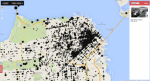
What did the Sunset neighborhood of San Francisco look like in 1904? Now you can find out with this wonderful geotagged map of San Francisco. Through geocoding, photos from the San Francisco Public Library's Historical Photograph Collection were associated with latitudes and longitudes to link up photos to their various locales within the city. Visitors can zoom in and out of the map to explore thousands of photos from 1850 to 2000. There isn't a way to search all of the images, so visitors will have to be resourceful and browse around, which is actually quite fun. A great place to start is by looking at some of the dozens of photos of Mt. Davidson, including some rather dramatic Easter Sunrise Service images from 1930. It's also neat to look at Candlestick Park Cove and its sprawling industrial area, complete with road infrastructure and other interesting projects.
Archived Scout Publication URL
Scout Publication
Publisher
Classification
GEM Subject
Data Type
Language
Date of Scout Publication
May 2nd, 2014
Resource URL Clicks
105
Internal
Cumulative Rating
0
Comments