The Making of the British Landscape: From the Ice Age to the Present
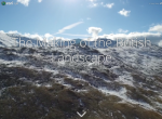
Renowned geographer Nicholas Crane and the UK branch of the Environmental Systems Research Institute (ESRI) have teamed up to create this engaging story map about the geological history of Great Britain. Crane is an award winning writer and documentarian and currently serves as the president of the Royal Geographical Society; ESRI is an international company that creates GIS software. This story map traces the history of Great Britain from 12,000 years ago, when "Britain was the colourless, glacial extremity of a continuous landmass," to the present. With traditional and interactive maps, gorgeous photographs, and lively prose, this story map illustrates natural phenomena and human endeavors. Highlights include a three-dimensional diagram of Silbury Hill, the largest human-made mound in Europe, and the earliest surviving map of Scotland, created by Timothy Pont in the late sixteenth century. Those interested in learning more may want to read Crane's book of the same title.
Archived Scout Publication URL
Scout Publication
Creator
Publisher
Classification
GEM Subject
Language
Date of Scout Publication
January 6th, 2017
Resource URL Clicks
118
Comments