Civitates Orbis Terrarum
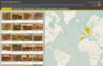
The Civitates Orbis Terrarum was an atlas of cities around the world published between 1572 and 1617 and edited by Cologne-based cleric, Georg Braun. The atlas contained no fewer than 546 "bird-eye and map views of cities all over the world" including Mexico D.F., Mexico; Budapest, Hungary; Alexandria, Egypt; and Warsaw, Poland. The Clemson Center for Geospatial Technologies has made a select number of these maps available via the Historic City Projects. On this interactive map, powered by Esri, visitors can view some of the maps that appeared in the atlas's six volumes. While some of these maps (like the detailed 1588 depiction of Bologna, Italy) offer the kind of street details that we're used to seeing on contemporary maps, others appear more like an illustration than a map to modern eyes. As a result, this collection offers a fascinating glimpse into the history of cartography.
Archived Scout Publication URL
Scout Publication
Classification
GEM Subject
Language
Date of Scout Publication
July 7th, 2017
Resource URL Clicks
221
Comments