The Journey of a Semipalmated Sandpiper
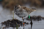
The Western Hemisphere Shorebird Reserve Network and the environmental non-profit organization Manomet have created this stunning story map dedicated to the migratory patterns of the semipalmated sandpiper. In the summer of 2016 at Coats Island in Hudson Bay, a research team tagged a number of these sandpipers with geolocators in order to learn more about the teeny bird's annual journey across North America, over open-ocean into Brazil, and back north to Hudson Bay. This story map combines gorgeous photography, maps, and videos to demonstrate how the semipalmated sandpipers survived on their trek and to highlight threats to the bird's habitat. Visitors can explore this story map in English, Spanish, or Dutch.
Archived Scout Publication URL
Scout Publication
Classification
GEM Subject
Date of Scout Publication
January 12th, 2018
Resource URL Clicks
101
Comments