Naonaiyaotit Traditional Knowledge Project Atlas
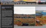
Visitors to the Naonaiyaotit Traditional Knowledge Project Atlas (NTKP) will be treated to a wealth of Inuit knowledge about Canada's Nunavut territory, accompanied by maps, images, and videos. Readers will find copious First Nations wisdom organized into categories, including traditional place names, Inuit values and way of life, and knowledge and stories of numerous wildlife species. This highly visual resource is built on Esri's Story Maps platform. As viewers scroll through the rich narrative texts in each category, accompanying images and colorful maps appear alongside to illustrate each passage, creating an interactive experience. For example, scrolling through the "Caribou" category reveals an overview of the caribou's significance to the Inuit with a color-coded map of the region's three main caribou herds, a map showing caribou migration paths alongside a narrative of the Inuits' seasonal interactions with the herds, descriptions of caribou habitats and life histories with accompanying maps and images, and much more. NTKP is a collaborative project between the Kitikmeot Inuit Association, Dominion Diamond Mines, Dalhousie University, and Esri Canada. The project's name, Naonaiyaotit, roughly translates to "seeking knowledge in an attempt to understand," and this intent is reflected clearly in this valuable resource.
Archived Scout Publication URL
Scout Publication
Publisher
Classification
GEM Subject
Language
Date of Scout Publication
August 17th, 2018
Resource URL Clicks
58
Comments