National Geographic: Where we live, block by block
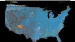
As part of their "Diversity in America" series, National Geographic has created this fascinating interactive map (viewable for free after entering an email address) depicting where America's different races live and at what concentration. Readers can search for any US city via the map's search box or use the zoom tools in the bottom right to see their area of interest, while a helpful legend explains what the different colors signify. Some of the map's most interesting features are pointed out in the Regions worth exploring menu. Here, various patterns of diversity and development history are highlighted in Los Angeles, Houston, Chicago, New York City, and Washington, DC. This section also spotlights locations where different aspects of American history can be seen reflected in its demographics, such as legacies of sharecropping in Virginia. This map was created for National Geographic by Matthew W. Chwastyk, Kennedy Elliott, and Ryan Morris. In their words, "mapping [America's] diversity reveals not just a snapshot of today but the imprint of two and a half centuries of migration, conflict, and prosperity."
Archived Scout Publication URL
Scout Publication
Publisher
Classification
GEM Subject
Language
Date of Scout Publication
October 26th, 2018
Resource URL Clicks
521
Comments