ORBIS: The Stanford Geospatial Network Model of the Roman World
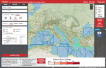
Map aficionados, scholars, and general audiences alike may be interested in ORBIS: The Stanford Geospatial Network Model of the Roman World. This fascinating project is an interactive model of the Roman Empire that "reconstructs the time cost and financial expense associated with a wide range of different types of travel in antiquity," including movement by road, river, and sea with multiple travel modes available for each. ORBIS consists of 632 locations and covers approximately four million square miles of territory, creating a multi-modal network model of the Roman Empire that allows visitors to gain a more accurate understanding of how people, goods, and information flowed in ancient Rome. For new users, ORBIS provides an extensive introduction and tutorial explaining the research behind the model and how to use it to map routes between different locations. Visitors can also find examples of scholarly articles and working papers that incorporate ORBIS into their research. Users may also create their own maps, cartograms, or diagrams in ORBIS and export them as vector files. ORBIS was created collaboratively between an interdisciplinary team at Stanford University led by historian Walter Scheidel and digital humanities specialist Elijah Meeks. Visitors to this site may want to note that this site works best in Chrome and Safari browsers.
Archived Scout Publication URL
Scout Publication
Publisher
GEM Subject
Language
Date of Scout Publication
January 4th, 2019
Resource URL Clicks
303
Comments