Charles Darwin and the Voyage of the HMS Beagle
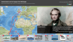
Today the place many people most strongly associate with Charles Darwin is the Galapagos Islands, but Darwin's historic voyage on the HMS Beagle encompassed far more than is often realized. This story map by Esri's Matt Artz combines geography and history to create an interactive spatial timeline of Darwin's journey that incorporates the famed naturalist's own words and period imagery (with some contemporary photographs). Visitors can navigate this global journey by the row of thumbnails at the bottom, and they can also zoom in and out of the map. The story begins at Devonport, England, from which the Beagle's voyage launched in December 1831. From there, the story map takes visitors on a multi-continent tour along Darwin's route, with stops that include the Canary Islands and the Cape Verde Islands off the coast of Africa, various points in Brazil, and Tierra del Fuego at the southern tip of the Americas, before reaching the Galapagos Islands in September 1835. The voyage continues across the Pacific Ocean, reaching New Zealand and Australia before crossing the Indian Ocean to Mauritius and South Africa, ultimately crossing the Atlantic a second time before returning to England in 1836.
Archived Scout Publication URL
Scout Publication
Creator
Classification
GEM Subject
Language
Date of Scout Publication
April 5th, 2019
Resource URL Clicks
238
Comments