Esri: Landsat Explorer
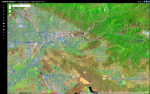
For fans of interactive maps and geospatial visualizations, Esris Landsat Explorer is a welcome boon, providing access to publicly-available imagery from the Landsat Program, a satellite program run jointly by NASA and the US Geological Survey that has focused on observing Earths land surfaces since its start in 1972. Esris Landsat Explorer, launched in 2017, is a sophisticated web app that enables users to visualize our planet and understand how the Earth has changed over time, with more than 40 years of data available. New users may want to begin by checking out the web apps tutorial (denoted toward the bottom of the menu on the left by a graduation cap icon), which provides a thorough introduction to Landsat Explorers various imagery and analytical tools, such as more than a dozen different renderings of Landsat band combinations, a mask tool, and a change detection tool to compare two different points in time. In addition to using Landsat Explorers built-in data, users can add data from ArcGIS Online to the web app as well as save their top layer in Landsat Explorer to ArcGIS Online, and they can also download their top layer as a TIF image.
Archived Scout Publication URL
Scout Publication
Classification
GEM Subject
Language
Date of Scout Publication
July 26th, 2019
Resource URL Clicks
184
Comments