A History of California Wildfires
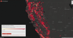
Readers who have been following the recent news reports about this year's wildfires in California may be interested in this interactive map from the Sacramento-based Capital Public Radio. Published in January 2019, this map displays in one place "the perimeters of more than 100 years of California wildfires recorded by Cal Fire and the U.S. Geological Survey," including fires that occurred as early as 1878 and as recently as 2018. Upon visitors' first arrival, the map shows the locations of all its wildfires simultaneously. A slider allows visitors to view the fires for an individual year (available from 1951 to 2018), but all fires from 1878 to 1950 are shown together since the data for these years is incomplete. Users can zoom in and out of the map to view a particular area in greater detail, and clicking on a specific fire will show its name and the year it started. This map was created by Emily Zentner and Chris Hagan, who are respectively the Interactive Producer and the Senior Editor of Digital Content for Capital Public Radio.
Archived Scout Publication URL
Scout Publication
Creator
Publisher
Classification
GEM Subject
Language
Date of Scout Publication
November 8th, 2019
Resource URL Clicks
239
Comments