Canals
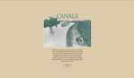
Several of the University of Richmond's American Panorama maps have been featured in past issues of the Scout Report. Like its sister projects, Canals combines historical analysis with interactive imagery for a superb user experience. Canals were a vital part of the emergence of American markets, connecting ports and shaping trade channels. These waterways also influenced "American regionalism" by broadening the capacity for geographic areas to connect. On the map, users can choose one of the dozens of canals available. This selection reveals a synopsis of the canal's physical features and location, as well as its economic purpose. Plus, a scrollable map and timeline allow users to better understand the relationships between different canals. The map's data were largely pulled from Jeremy Attack's 19th Century Canals. A full list of sources is available by clicking the "About this Map" link in the top-left corner. Canals was created by several members of Richmond's Digital Scholarship Lab team, including Robert K. Nelson, Scott Nesbit, Edward L. Ayers, Justin Madron, Nathaniel Ayers, and Beaumont Smith. It is supported by the Andrew W. Mellon Foundation.
Archived Scout Publication URL
Scout Publication
Publisher
Classification
GEM Subject
Language
Date of Scout Publication
March 5th, 2021
Resource URL Clicks
202
Comments