Description of the Ecoregions of the United States
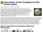
An electronic (interactive) version of a 1995 publication by the US Forest Service (USFS), this site is based on the National Hierarchical Framework of Ecological Units, designed to provide "a standardized method for classifying, mapping, and describing ecological units" in the US. The "Ecoregions of the United States" contains three simple color maps of the United States (including Alaska, Hawaii and Puerto Rico) showing generalized ecological boundaries. At the coarsest spatial scale, the Ecosystem Domains map delineates Dry, Humid Temperate, and Humid Tropical Domains. At the intermediate scale, an Ecosystem Divisions map delineates more than a dozen ecosystem types, ranging from tundra to rainforest. At the finest scale, over 50 Ecosystem Provinces are delineated. By clicking on a color type for any map (i.e., an ecosystem type), users may access further information on the abiotic and biotic characteristics within that ecosystem.
Alternate Title
Baileys' Eco-Regions (July 1995)
Archived Scout Publication URL
Scout Publication
Creator
Publisher
Classification
GEM Subject
Date Issued
1995
Language
Date of Scout Publication
October 30th, 1998
Resource URL Clicks
13
Internal
Cumulative Rating
0
Comments