Late 19th and Early 20th-Century Urban Rail Transit Maps
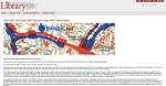
The last decades of the 19th century and those of the early 20th century were the heyday of urban rail transit around the world. These remarkable maps from the University of Chicago Library's Map Collection illustrate the history of such matters between the 1860s and the 1920s. On its homepage, the site offers a bit of historical context on the development of such systems and visitors would do well to read this area first. In total there are almost two dozen maps, including one of London's District Railway in 1885 and a fine map of Chicago's street car lines in 1897. Visitors can look over the provenance information for each document or read a brief description of each map as well.
Archived Scout Publication URL
Scout Publication
Publisher
Classification
Required Software
Language
Date of Scout Publication
March 7th, 2014
Resource URL Clicks
145
Internal
Cumulative Rating
0
Comments